British Isles Maps and Views
| FEATURED MAPCO BRITISH ISLES MAP |
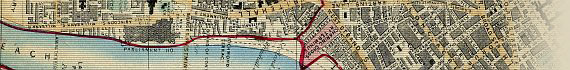
| ~ An Entirely New & Accurate Survey Of The County Of Kent, With Part Of The County Of Essex 1801, by Captain William Mudge ~ |

|
** With Full Place Name Search **
This highly detailed map of Kent was the first Ordnance Survey map to be published. The survey was commenced in the 1790s by the Board of Ordnance (later the Ministry of Defence), in response to the feared invasion of England by the French. Kent, the first Ordnance Survey map, was published on 1st January 1801 by William Faden, Geographer to the King.
Captain Mudge's Survey of Kent is one of the finest maps displayed on the MAPCO website.
|
Map Of North West Kent
1789

The Country Twenty-Five Miles Round London Planned From A Scale Of One Mile To An Inch
By William Faden 1789
** With Full Place Name Search **
|
Turnpike Gates In The Vicinity Of London
1790

Cary's General Plan For Explaining The Different Trusts Of The Turnpike Gates In The Vicinity Of The Metropolis
1790
|
Map Of Dublin
1798

Modern Plan Of The City And Environs Of Dublin. Including The Grand & Royal Canals, New Docks, &c.
1798
** With Full Street Search **
@ dublin1798.com
|
Map Of London Environs
1800

Topographical Map Of The Country
Twenty Miles Round London,
1800
|
Map Of Kent
1801

An Entirely New & Accurate Survey
Of The County Of Kent,
With Part Of The County Of Essex
by Captain William Mudge
1801
** With Full Place Name Search **
|
Map Of Oxfordshire
1801

A New Map Of The County Of
Oxford Divided Into Hundreds.
Printed for C. Smith
January 6th, 1801
|
Geological Map Of England & Wales
c1836

Walker's Geological Map Of England, Wales, And Part Of Scotland c1836
|
Environs Of London
1837

Thomas Moule's
Environs Of London
1837
|

Map Of Ireland
1838

Map of Ireland, Compiled from the Surveys of the Board of Ordnance and other approved Documents
By J. & C. Walker
1838
@ ireland1838.com
|
Map Of England & Wales
c1840

Map of England & Wales
Divided into Counties,
Parliamentary Divisions
and Dioceses.
Shewing the Principal Roads,
Railways, Rivers & Canals,
&c., &c.,
Published by S. Lewis & Co.,
London.
c1840
|
Map Of Scotland
c1840

A Map of Scotland
Divided Into Counties
Shewing The Principal Roads,
Railways, Rivers, Canals , Lochs,
Mountains, Islands &c.
On A Scale Of
Five Miles To An Inch.
Published By Samuel Lewis & Co.,
87 Aldersgate Street, London.
c1840
|
Map of England & Wales
1840

Pigot & Co.'s New Map Of England & Wales, With Part Of Scotland 1840. Including The New Lines Of Canals, Rail Roads, &c.
|
Map Of Scotland
c1847

Betts's New Map Of Scotland
Embracing All The Principal
Objects Of Interest To The Tourist,
And Shewing The Various Lines Of
Railroad, The Turnpike And
Principal Cross Roads, Canals,
Lakes, Rivers, &c &c.
c1847
|
Map Of Berkshire - Windsor Forest
1856

A Map Of Windsor Forest And Its Vicinity 1823, By Henry Walter.
New Edition Revised And Corrected By Alfred E. Harrison
1856
|
Map Of Bristol & Clifton
c1863

Lavars's New & Improved
Map Of Bristol & Clifton
c1863
|
Map Of London Environs
c1872

Wyld's New Topographical Map Of The Country In The Vicinity Of London, Describing All The New Improvements, Metropolitan Boroughs And Parish Boundaries c1872
|
Map Of Surrey
1874

Map Of The County Of Surrey From Trigonometrical Survey With The Roads,
Parks & Railways, By James Wyld, Geographer To The Queen,
1874
** With Full Place Name Search **
|
Map Of Middlesex
c1883

Groom's New Map
Of Middlesex
c1883
|
More British Isles Maps
Coming Soon...
|
Upcoming British Isles Items
To aid students, historians, and genealogists tracing their ancestry, some of
the following England and English county maps and views will be selected for display
in coming months:
Panorama Of Dublin
1846

The City Of Dublin.
Being No. 1 Of A Series Of Views Of The Principal Capitals In Europe.
Presented Gratis To The Subscribers To The Illustrated London News.
Supplement to the Illustrated London News.
For The Week Ending Saturday, June 6, 1846
|
- 1695 ~ Bark Shire, by Robert Morden in (From Camden's Britannia 1695)
- 1761 ~ England And Wales. Drawn From The Most Accurate Surveys Containing All The Cities And Boroughs, Towns And Villages In Which Are Included All The Improvements And Observations Both Astronomical And Topographical Which Have Been Made By Members Of The Royal Societies And Others Down To The Present Year The Whole Corrected & Improved By John Rocque. (Sold by T. Jefferys, Geographer To Ye King. Charing Cross, London. 1761.)
- 1790 ~ A Plan Of The Town & Harbour Of Whitehaven In The County Of Cumberland. From An Actual Survey Anno 1790 By J. Howard.
- 1794 ~ Cary's New Map of England and Wales With Part of Scotland, on which are carefully laid down all the direct and principal cross roads, the course of the rivers and navigable canals, cities, market and borough towns, parishes, and most considerable hamlets, parks, forests &c. &c., Delineated from actual surveys and materially assisted from authentic documents, liberally supplied by
the Right Honourable the Post Masters General (Published June 11th. 1794 by J. Cary, London)
- 1801 ~ A New Map Of Northamptonshire Divided Into Hundreds Exhibiting Its Roads, Rivers, Parks, &c. By John Cary, Engraver, 1801 (London. Published By John Cary, Engraver & Map Seller. No. 181, Strand. Dec. 21st, 1801)
- 1807 ~ Laurie & Whittle's New Map Of The County Of Kent, Divided Into Its Laths, With Their Modern Subdivisions. Exhibiting The Whole Of The Mail, Direct, & Principal Cross Roads, Gentlemens Seats, Navigable Canals, Rivers &c. Laid Down From Astronomical Observations Published In The Philosophical Transactions. By Nathl. Coltman. 1807 (Published July 20th, 1807, By Robt. Laurie & Jas. Whittle, 53 Fleet Street, London. )
- 1812 ~ Wallis's New British Atlas Containing a Complete set of County Maps Divided into Hundreds (London. Published By James Wallis. 1812)
- c1820 ~ The Grand Southern Tour Of England, Including A Principal Part Of The East, West, & Inland Counties, Patronised By Her Majesty The Queen, His Royal Highness The Prince Regent, His Royal Highness The Commander In Chief, Several Others Of The Royal Family, The Universities Of Oxford & Cambridge, A Great Part Of The Bench Of Bishops, And Nearly Two Thousand Noblemen & Gentlemen.
1st Edition? Size 179cm x 101.5cm (Published By M. Phillips, Civil Engineer & Surveyor. Engraved, Printed, & Sold By Jon. Hebner, 15, Great Maddox Street, Hanover Square, London.)
- c1828 ~ PLAN of Edinburgh & Leith. Exhibiting all the PRESENT & INTENDED IMPROVEMENTS, And all the Roads &c. in the Vicinity of the City, Correctly Delineated. Size 50cm x 40cm (Published Edinburgh, c1828.)
- 1836 ~ Map Of Dublin. Hand coloured in outline. Size 34cm x 51cm. (Published under the Superintendance of the Society for the Diffusion of Useful Knowledge. London: Published by Baldwin & Cradock, 1836.)
- 1838 ~ Map Of Ireland. To Her most gracious Majesty Queen Victoria, This Map of Ireland, Compiled from the Surveys of the Board of Ordnance and other approved Documents By J. & C. Walker, Is with Her Majesty's gracious permission Most Respectfully Dedicated. (Hand coloured map, dissected, and mounted on linen. Size 154cm x 124cm. Published by Edward Holt, Liverpool, 1838.)
- 1842 ~ A New And Accurate Map Of The County Of Cornwall From An Actual Survey Made By Thos Martyn (Original map published 1748. Printed For James Wyld, Geographer To The Queen, Charing Cross, East, London. 1842. Size: 42" x 31" (107cm x 79cm). Scale: 1" : 2 Miles. Reprint of Thomas Martyn's original map dated November 26th, 1748.)
- 1846 ~ The City Of Dublin. Being No. 1 Of A Series Of Views Of The Principal Capitals In Europe. Presented Gratis To The Subscribers To The Illustrated London News (Supplement to the Illustrated London News. For The Week Ending Saturday, June 6, 1846. Size: 40cms x 109cms (15¾" x 43") Engraved Panoramic View Of Dublin.)
- 1848 ~ Panorama of Edinburgh. Illustrated London News. Sheet Size: 1040mm x 460mm (41" x 18"). Image Size: 915mm x 318mm (36" x 12½"). Includes a Key To The View Of Edinburgh (Given With The "Illustrated London News" Nos. 324 and 325). (Published with the Illustrated London News, Saturday, 8 July 1848)
- c1850 ~ New Map Of The County Of Essex. Label reads Collins' Railway Map Of Essex. (H.G Collins, Charing Cross, London)
- 1854 ~ From The Ordnance Survey Of The Country Thirty Miles Round London. Additions To 1854 (Published By G F Cruchley, Mapseller & Globe Maker, 81 Fleet Street, London. Additions To 1854. Size: 127cm x 101.5cm (50" x 40"). Scale 1" : 1 Mile. Hand-coloured map of the Environs of London, dissected and mounted on linen.)
(Hyde records this as Howgego No. 333)
- 1856 ~ A Map Of Windsor Forest And Its Vicinity 1823, by Henry Walter. (Engraved By J. Dower. New Edition revised and corrected by Alfred E. Harrison and published by J. B. Brown, Windsor, and James Wyld. 1856. Size: 127cm x 91.5cm (50" x 36"). Scale 2.5" : 1 Mile. Hand-coloured map of Berkshire, showing the Twyford, Windsor & Sandhurst district of east Berkshire, with field boundaries and owner's names. Dissected and mounted on linen.)
- 1857 ~ Somerset, Glamorgan, Bristol Channel. Sheet 17 of Cruchley's Reduced Ordnance Map of England & Wales. Planned Upon A Scale Of Two Miles To An Inch (G.G. Cruchley, Map-Seller & Globe Maker, 81 Fleet Street. 1857)
- 1863 ~ Liverpool, by B.R. Davies (Benjamin Rees Davies. The Weekly Dispatch Atlas, 1863.)
- 1864 ~ Panorama of Glasgow. Large Picture Plan Or Birds Eye View Of The City of Glasgow. Engraved On A Supplemental Sheet. Supplement To The Illustrated London News, March 26, 1864. Sheet Size: 1155mm x 540mm (45½" x 21¼"). Image Size: 1035mm x 402mm (40¾" x 15¾"). Includes A Key To The View Of Glasgow. (Artist: Thomas Sulman. Published as a Supplement to the Illustrated London News, Saturday, 26 March 1864)
- 1865 ~ The British Atlas, comprising separate Maps of every County in England each riding in Yorkshire and North & South Wales showing the Roads, Railways. Compiled from the Maps of the Board of Ordnance and other Trigonometrical Surveys, by J. & C. Walker. 46 Counties on double sheet 440mm x 370mm (Published by Longman, Rees & Co. Paternoster Row, and J. & C. Walker, 9 Castle Street,
Holborn. 1865)
- c1873 ~ Environs Of London Ordnance Survey Map Series. Scale 1" to 1 mile. 7 Maps (of 8) (Colonel Colby 1844. Published c1873)
- c1878 - Map Of The Borough Of Bedford From Actual Survey In The Years 1876-1878 By Francis Thomas Mercer Surveyor &c Bedford (F.T. Mercer, Surveyor, Bedford. Engraved And Printed By Shaw & Sons, Fetter Lane, London. Published For The Proprietor At His Offices, Bedfordshire Times Buildings, High Street, Bedford. )
- c1880 ~ Middlesex and Surrey. Sheets 256 & 270 of Stanford's New 1 Inch Survey of England And Wales. (London: Edward Stanford, Geographer To Her Majesty, 26 & 27, Cockspur St. Charing Cross, S.W.)
- c1880 ~ Reduced Ordnance Survey around Ipswich. (Published by G. Richmond, Nechells Park Road, Birmingham. c1880. Size: 150cm x 140cm (59" x 55"). Scale 1" : 2 Miles. Printed colour map of London and the eastern counties of England, dissected and mounted on linen.)
- c1882 ~ W.H. Smith & Son's Map Of Environs Of London. Scale 1 Mile to an Inch (W.H. Smith & Son, 186 Strand, c1882)
Hyde No. 171 (4)
- 1886 ~ Birds Eye View Of Liverpool, From The Mersey, With All The New Public Buildings (From 'The Illustrated London News,' May 1886)
- c1890 ~ Cruchley's Road and Railway Map of the County of Hertford, Showing all the Railways and Names of Stations, also the Turnpike Roads, Villages, Gentlemens Seats, &c. &c. (London: Published by Gall & Inglis, 25 Paternoster Square. c1890)
- c1890 - Cruchley's Road and Railway Map of the County of Gloucester, Showing all the Railways and Names of Stations, also the Turnpike Roads, Villages, Gentlemens Seats, &c. &c. (London: Published by Gall & Inglis, 25 Paternoster Square. c1890)
- c1890 - Bacon's Map of Cambridgeshire (London: G.W. Bacon & Co. Ltd, Strand. c1890)
- c1890 - The New Collotype Album of Sixteen Views of Wokingham. (Photographed and Printed by Chester Vaughan. c1890)
- c1890 - View Album of Wokingham And Neighbourhood. (Published by W. J. Gotelee, Bookseller and Stationer, Market Place, Wokingham. Photographed and Printed by Chester Vaughan. c1890)
- c1895 - New Plan Of Dublin And Suburbs. Cover Title: Bacon’s Large Scale Plan of Dublin for Cyclists and Tourists. Size: 82cm x 70 cm. Scale: 6" : 1 Mile. Description: Folding paper map in illustrated red cloth covers. (Published by G.W. Bacon, London. c1895)
- c1897 ~ Geological Map Of England & Wales, Reduced Chiefly From The Ordnance And Geological Surveys Under The Direction Of Sir Archibald Geikie. D.Sc., L.L.D., F.R.S., Director General of the Geological Survey. Topography by John Bartholomew, F.R.G.S. Scale 1:633,600 or 10 Miles to an Inch. Published with Government Authority. (Published by John Bartholomew, c1897)
- c1900 - Bacon's Excelsior Library Map of Surrey and Parts of Adjoining Counties (London: G.W. Bacon & Co. Ltd, 127 Strand. c1900)
- 1909 - Map Of The City Of Glasgow Shewing The Original Area In The Twelfth Century, And The Areas Which Have Been Added From That Period Until The Present Time. 1909.
|