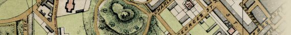
Lavars's New & Improved Map Of Bristol & Clifton c1863
The Atlas
| Full Title: |
Lavars's New & Improved Map Of Bristol & Clifton c1863.
Lithographed & Published By Him At Broad Street Hall, Bristol. |
|
|
| Cover Title: |
Pocket Guide To Bristol And Suburbs, With More Than One Thousand References To Streets, Buildings, &c.
And A Large Map.
Printed In Colours, Dissected & Mounted On Cloth,
Price 3x. 6d.
Bristol: J. Lavars, And All Booksellers.
London: Houlston & Wright, Paternoster Row.
This Map Can Be Had In A Frame, With Glass; Or The Cheap Editions, Plain, One Shilling And Two Shillings.
|
| Publisher: |
J. Lavars, Broad Street Hall, Bristol
|
| Date: |
c1863 |
| Size: |
62.5cm x 49cm (24½" x 19¼") |
| Scale: |
73/8" : 1 Statute Mile |
| Extent: |
Claremont Crescent - Barrow House - Windmill Hill - Bower Walls |
| Description: |
Machine coloured map, dissected and mounted on linen. Folds into hard card case, with paper label. An interesting and rare antique map of Bristol & Clifton.
|
| |
Includes an index to streets and buildings, but many streets and lanes are not labelled on the map.
A main point of interest is that this map was produced between the recommencement of work on the Clifton Suspension Bridge in 1862, and its completion in 1864.
Extremely useful for finding Bristol streets in the 1861 Census, this is a very rare map of Bristol from this period.
|
How To Use These Map Pages
Use the thumbnail map at the top of each page to navigate your way around the map. Hovering your mouse pointer over the thumbnails will highlight the individual map sections, and display a pop-up message showing the notable landmarks, streets and buildings from the northern to southern extent of that section.
Click the desired area to jump to a page displaying a full size image of that map section. You will need to scroll down the page a little to see the map image. A coloured thumbnail image on the thumbnail map at the top of the page will show you which section of the entire map you are currently viewing.
Click To Enlarge
Once you are viewing the desired map section, you can click on the map image to view an enlarged image of that section. Clicking on the displayed map image allows you to switch back and forth between the normal sized image and the enlarged view of the map section.
|


, St Vincents Rocks, Hotwell House, River Avon, Bower Walls, & Rownham House")